provided features

Our Products

Hidrokinetik Technologies Sdn. Bhd. takes pride in offering high standards of customer-centric service that is backed by sound technical expertise in developing new innovative autonomous survey vessel to the marine/energy industry. Regardless on inner water or at sea, we will go the extra mile to respond to a critical call, upholding the very values that reflect the spirit of our company

autonomous-navigation

Autonomous Navigation

real-time-icon

Real Time Data Collection

local-solution

​Localised Solution

Our Ability

Remotely Operated Vehicle (ROV)

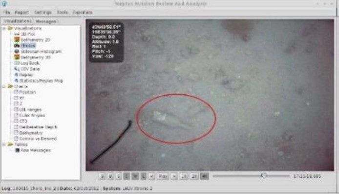
ROVs enable intricate surveys of the seabed enabling the collection of precision samples from the seafloor. Experiments at extreme water depths unreachable by human divers, due to the water pressure, are also possible with the ROV. Through its eyes (cameras), the manipulators (hands) can recover small, delicate objects more precisely than any other sampling system.

Unmanned Surface Vessel (USV)

Our Autonomous Hydrographic Surface Vessel which is a type of USV contains multiple features to ensure optimized performance. The vessel is equipped with autonomous navigation with obstacle avoidance capability to avoid collision with any external bodies. The Data Collection is in real time for more accurate quality control and precise data monitoring.  Our USV are powered by electric which is sustainable and environmental friendly. The built of this product is specifically designed to work well  in tropical climate.

SURAYA-I

Suraya I is the first USV made by Hidrokinetik. It has a small length of 1.04 meter and only weighs  9.5 kg in total. The USV utilizes single beam for its survey system.  This vessel can manage up to 2 hours operating on a single speed of 4 knots (2 m/s) 

SURAYA-II

Suraya II is the upgraded version of Suraya I. It is made slightly bigger with the length of 1.5 meter, width of 0.4 meter and 15.5 kg in weight. The vessel can maintains heavier payload compared to its predecessor. This USV employs multi beam for its survey system for more detailed mapping performs at speed range of 1-3 knots with operating time of 8 hours and 2 hours respectively.

Hydrosense RTG

Thermal Imaging

South East Asia's Authorized Distributor

DISCOVER THE BEST CASE FOR YOUR NEEDS

The perfect protection for your equipment.